.
Course Description
Instructor(s):
M. Ersen AKSOY (Dr.)
Jean-Luc REIGNER (Dr.)
Course Code / Semester: GEOE 3018 / Spring
Level: Undergraduate
Pre-requisites: GEOE 3003 Structural Geology
Assessment:
Midterm: %25 (Geological Field report)
Class work: %25 (Geological map, cross-section (%15) + earlier field reports/excercises (%10))
Final: %50 (Geological report, geological map, cross-section, presentation (%35) + individual performance and oral examination (%15))
Course Highligts: This course features lectures, lab exercises and largely field trips. After the 3rd week, each course will be executed in the field.
Course Description: This course is based on outdoor exercises to provide students practical experience in geological mapping. We organize weekly field trips to various localities within the Muğla province. Students learn 1- to identify, describe and map rocks, fossils and structures; 2- how to prepare a geology map and write a technical report. The trips provide an overview on the geological properties of the Menderes massif, Lycian nappes, Beydağ Autochthon and related cover sediments. Besides, the ongoing extensional tectonism in the area allows remarkable observations on continuing geomorphic processes. See the course calendar for more information on excursion destinations.
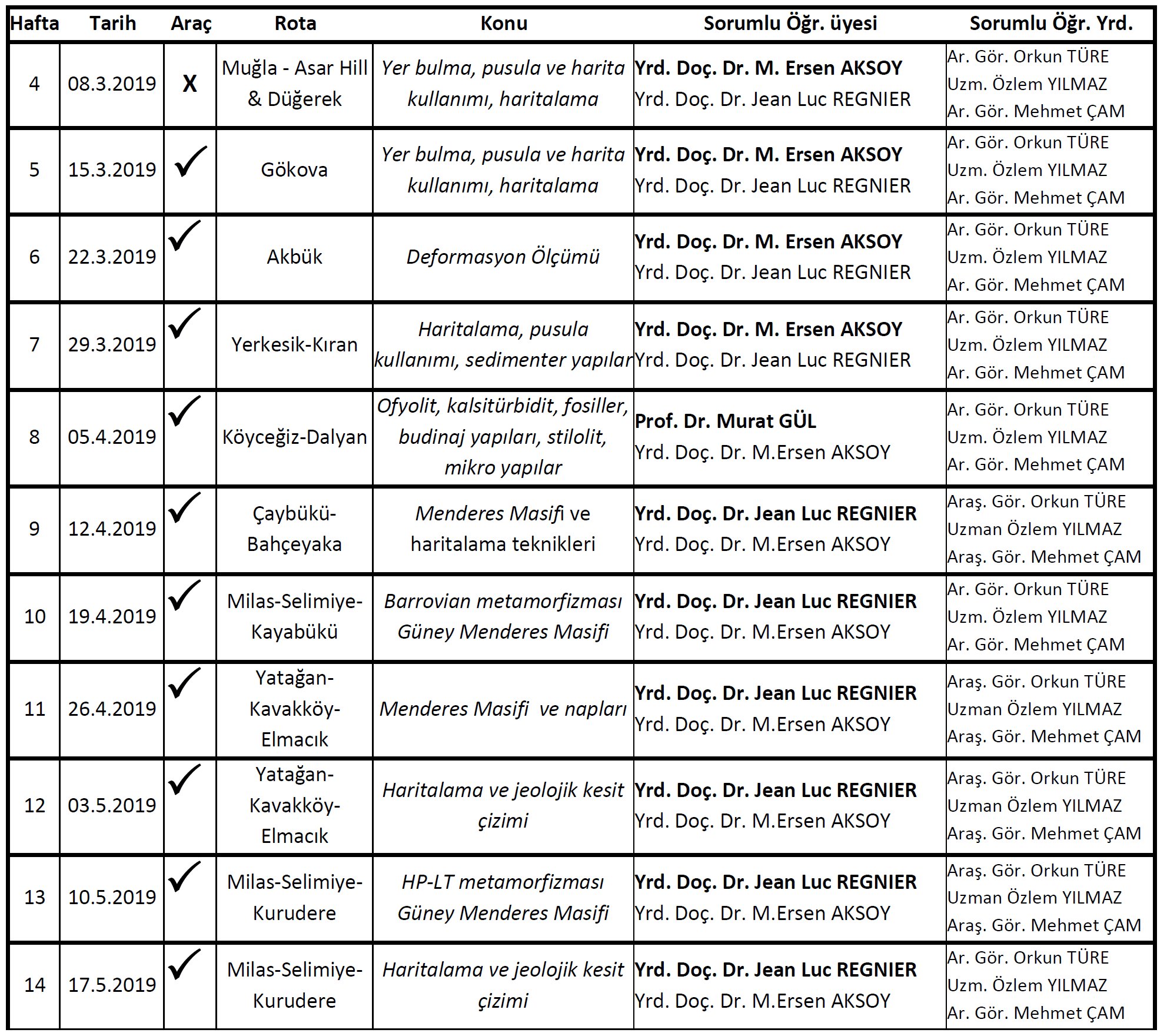
Field Trip Calendar
Tools
Students are expected to bring their course materials on each trip. Besides if you have a smartphone, install the below mentioned applications on your device.
Course materials:
- Field notebook
- Colour Pencils (set of 12)
- Ruler (min 30cm in length)
- Triangle protractor
- 2 x Pencil (HB, B)
- Needle-point pencil (≤ 0.5)
- Soft rubber/eraser
- Pencil sharpener
- Transparent papers (10 pages)
- Squared paper (millimetric, 10 pages)
- Clipboard with cover
Smartphone Apps
 Field Move Clino
FieldMove Clino is a digital compass-clinometer for data capture on your Android phone, designed for simplicity in the field, and optimized to use the device’s GPS location and orientation sensors.
Download for Android
Download for Iphone
 GPS Essentials
GPS Essentials is a GPS application with functions such as navigation, managing waypoints, recording tracks and routes etc.
Download for Android
Download for Iphone not available.
 Familiy Locator Life360
With Family Locator we will be able to see each other’s locations, send messages and make emergency calls in the field. This app is especially useful during the Field Geological Mapping camp.
Download for Android
Download for Iphone
Windows Applications
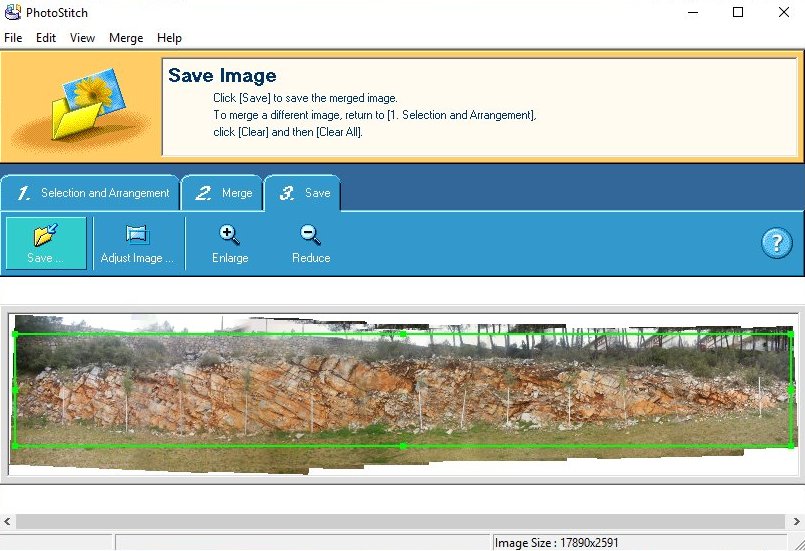
Canon Photo Stich
Canon Photo Stich is a Windows freeware that can be used to create panoramic images from multiple photographs. You can use to it create photo mosaics of geological outcrops. Requires no installion. Extract the zip file to a folder and run “stich.exe”.
Download for Windows
How to use Canon Photo Stich? Click here
Recommended Books
Lisle, R.J., 2004, Geological Structures and Maps, Elsevier Butterworth Heinemann.
Lisle, R.J., Brabham, P., and Barnes, J., 2011, Basic Geological Mapping, John Wiley & Sons, Ltd.
McClay, K.R., 1999, The Mapping of Geological Structures, John Wiley and Sons Ltd.
Tucker, M.E., 1991, The Field Description of Sedimentary Rocks, Wiley-Blackwell.
Fry, N., 2013, The Field Description of Metamorphic Rocks, Wiley.
Jerram, D., and Petford, N., 2011, The Field Description of Igneous Rocks, Wiley.
Publications
Aktimur, H.T., Sarıaslan, M.M., Sönmez, M., Keçer, M., Uysal, Ş., Özmutaf, M., 1996.Muğla ilinin (Merkez ilçe) arazi k ullanım potansiyeli MTA Etüd Raporu. (pdf)
Atalay, Z., 1980. Muğla – Yatağan ve Yakın Dolayı Karasal Neojen’inin Stratigrafi Araştırması. Bulletin of the Geological Society of Turkey 23, 3-99. (pdf)
Collins, A.S., and Robertson, A.H.F., 1999, Evolution of the Lycian Allochthon, western Turkey, as a north-facing Late Palaeozoic to Mesozoic rift and passive continental margin: Geological Journal, v. 34, p. 107-138. (pdf)
Erdoğan, B., and Güngör, T., 2004, The Problem of the Core – Cover Boundary of the Menderes Massif and an Emplacement Mechanism for Regionally Extensive Gneissic Granites , Western Anatolia ( Turkey ): Turkish Journal of Earth Sciences, v. 13, p. 15-36. (pdf)
Ersoy, Ş., 1990, Batı Toros (Likya) Naplarının Yapısal Öğelerinin ve Evriminin Analizi: Geological Engineering, p. 5-16. (pdf)
Gül, M., 2015, Occurrences of Chert in Jurassic-Cretaceous Calciturbidites (SW Turkey), Open Geosciences, Volume 7. (pdf)
Okay, A.I., 2008, Geology of Turkey: A Synopsis: Der ANSCHNITT, v. 21, p. 19-42. (pdf)
Rimmelé, G., Jolivet, L., Oberhänsli, R., and Goffé, B., 2003, Deformation history of the high-pressure Lycian Nappes and implications for tectonic evolution of SW Turkey: Tectonics, v. 22, p. (pdf)
Rimmelé, G., Oberhänsli, R., Goffé, B., Jolivet, L., Candan, O., & Çetinkaplan, M. (2003). First evidence of high-pressure metamorphism in the “Cover Series” of the southern Menderes Massif. Tectonic and metamorphic implications for the evolution of SW Turkey. Lithos, 71(1), 19–46. (pdf)
Whitney, D.L., and Bozkurt, E., 2002, Metamorphic history of the southern Menderes massif, western Turkey: Geological Society of America Bulletin, v. 114, p. 829-838. (pdf)
Lecture Notes
Under construction!
Web sources
– Here is a list of Geology Field Camps from around the world.
Safety
127 Hours
The movie “127 Hours” is an excellent example how easy it is to get in trouble in nature. You can find a full version of this movie on here on Youtube.
Here are some files that may be useful for you!
Course material
Week 04 – Gökova Topographic map: Download PDF
Week 07 – Çaybükü Topographic map: Download PDF
Week 11-12 – Elmacık – Kavakköy Topographic map: Download PDF
Week 13-14 – Kurudere Topographic map: Download 1/10.000 scale PDF or 1/25.000 scale PDF
Sample Files
-
Here are sample files for the technical report and newsletter.
Newsletter: Get the PDF or WORD version
Technical Report: Get the PDF or WORD versionHere is a guideline how to write a technical report (in Turkish): Get PDF